| Rapid Reconnaisance Survey | |||||||||||||||||||||||||||||||||||||||||||||||||||||||||||||||||||||||||||||||||||||||||||||||||||||||||||||||||||||||||||||||||||||||||||||||||||||||||||||||||||||||||||||||||||||||||||||||||||||||||||||||||||||||||||||||||||||||||||||||||||||||||||||||||||||||||||
The Objective of RRS is to demarcate and identify priority
watershed in the catchmnert area on 1:50K scale.It provides information on
physiography,slope, soil depth, surface texture, land use ,land cover, surface condition
and existing management practices.It deals
with identification and demarcation of very high and high priority subwatersheds in
catchment on 1:50K scale based on sediment yield/run-off potential index. SLUSI developed
a methodology for prioritization of subwatersheds in the catchment areas to facilitate
planning of soil and water conservation in a selective mode ad phased manner. The output
of the survey is utilised both by Central and State Governments towards formulation of
soil and water conservation working plan. It provides the following informations, which
could be beneficial to the planning processes. |
|
||||||||||||||||||||||||||||||||||||||||||||||||||||||||||||||||||||||||||||||||||||||||||||||||||||||||||||||||||||||||||||||||||||||||||||||||||||||||||||||||||||||||||||||||||||||||||||||||||||||||||||||||||||||||||||||||||||||||||||||||||||||||||||||||||||||||||
|
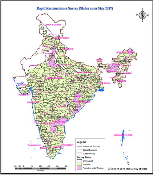
Rapid Reconnaisance Survey Status at a Glance : (Area in hectares) |
|||||||||||||||||||||||||||||||||||||||||||||||||||||||||||||||||||||||||||||||||||||||||||||||||||||||||||||||||||||||||||||||||||||||||||||||||||||||||||||||||||||||||||||||||||||||||||||||||||||||||||||||||||||||||||||||||||||||||||||||||||||||||||||||||||||||||||
| Publications of Rapid Reconnaisance Survey : Click for Reports : [Report-Wise] [State-Wise ] [Centre-wise] | |||||||||||||||||||||||||||||||||||||||||||||||||||||||||||||||||||||||||||||||||||||||||||||||||||||||||||||||||||||||||||||||||||||||||||||||||||||||||||||||||||||||||||||||||||||||||||||||||||||||||||||||||||||||||||||||||||||||||||||||||||||||||||||||||||||||||||
|
|
|||||||||||||||||||||||||||||||||||||||||||||||||||||||||||||||||||||||||||||||||||||||||||||||||||||||||||||||||||||||||||||||||||||||||||||||||||||||||||||||||||||||||||||||||||||||||||||||||||||||||||||||||||||||||||||||||||||||||||||||||||||||||||||||||||||||||||