Digital
Watershed Atlas of India |
||||||||||||||||||||||||||||||||||||||||
Watershed is a natural hydrologic entity governed by
the terrain topography from where runoff is drained to a point. The term watershed is a
general phenomenon thus its size and area depends on the scale of the base map used for
delineation and codification. Recognizing the importance of management of soil and
water resources in the country following the natural system, the department of Agriculture
and Cooperation developed the delineation and codification system and “Watershed
Atlas of A watershed can be symbolized as 1A2B3 where
“1” stands for River Resource Region, “A” designates the Basin in that
river resource region, “2” indicates the Catchment within the basin,
“B” indicates Sub catchment and “3” stands for the watershed number in
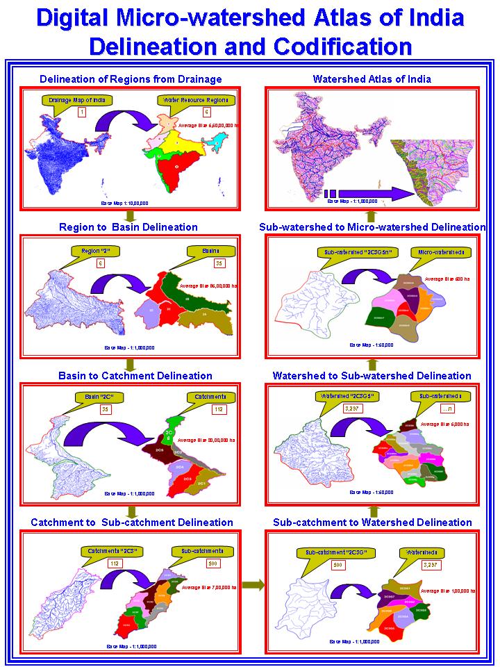
the sequence of stream hierarchy. Methodology: Delineation and Codification:-
The delineation has done in seven stages starting with Water Resource
Regions and their subsequent division and subdivisions into Basins,
Catchments, Sub-catchments, Watershed, Sub watershed and Micrwatersheds in
decreasing size of the delineated hydrologic unit. Each of the sub-catchment then divided into
watersheds following the lower order streams, a group of tributaries or the left and right
bank of higher order stream moving downstream upwards using the same base. When the left and right banks of a higher order
stream are being delineated as separate watershed it would be advisable to cut across the
stream at the upper end at a suitable confluence point to avoid the ambiguity in locating
the ridge. The
number of watersheds in a sub-catchment is restricted up to 9. The size of
individual subwatersheds is generally restricted around 5,000 to 9,000 hectares, which is
considered a viable working area for implemental programmes. The division of watershed is
restricted to 22 alphabets (avoiding a, e, i, l and o). The code of sub-watershed will be
2A1C1b. 1.
Water Resource Regions (WPR): The six WRRs
suggested by Dr. A. N. Khosla in 1949 have been adopted as such with slight modifications
in their numbering which has been done in a clockwise manner, starting with Indus drainage
as numbers like 1, 2, 3 etc. r r r Brahamputra drainage – 3 r All drainage flowing into the r All drainage flowing into the Arabian Sea except r 2.
Basins: Each WRR has been divided into basins
which constitute individual big rivers like Krishna, Narmada, Chambal etc. or a
combination of smaller ones which are contiguous to each other, such as basin between
Cauvery and Krishna have been divided into lower and upper basins or left bank and right
bank basins as in the case of Brahamputra. Basins are assigned letters as A, B,
C………..Z. 3.
Catchments: Each basin has been divided into a
number of catchments, which pertain to main tributaries or a group of contiguous
tributaries or individual streams. Catchments are represented by numerals suffixed to
basin code as 1, 2, 3…….9. 4.
Subcatchments: The catchments are further divided
into a number of sub-catchments, which are mainly smaller tributaries and streams.
Sub-catchments are indicated by suffixing alphabets to catchment code as A, B,
C………Z. 5.
Watersheds: Each subcatchments has been divided
into a number of watershed which are the smallest sized hydrologic units in the macro
level category on the base of 1:1 million scale in the Watershed Atlas of India, published
by SLUSI. Watersheds are designated by suffixing Arabic numbers to a code of subcatchment.
For example a watershed code would be like 4G4D3, 2B2A3 etc. The watersheds codes are
restricts to numerical 1 to 9 only. 6.
Subwatersheds: Each watershed is further divided
into sub-watersheds on 1:50000 scale (SOI topographical map) in which main tributaries and
streams are taken up for delineation of sub-watersheds. Subwatersheds designated by small English alphabets
as a, b, c………z which is suffixed to watershed code. The complete code of a
subwatershed is appeared as 2A2E8a, b, c, etc. The small alphabet ‘e’
‘i’ ‘l’ and ‘o’ are discarded in view of the cartographic
consideration and to avoid its ambiguity with the sequence of code. Hence, the total
numbers of codes for subwatersheds is restricted to 22. 7.
Micro Level Delineation: Planning to phase out the
watershed management at catchment level and to formulate action programme needs, micro
level delineation. The delineation of watershed boundary at micro level could easily be
attained by superimposing the watershed boundary from Watershed Atlas on to a drainage map
of 1:50000 scale. The delineation and codification would follow the similar system based on stream hierarchy and codification from downstream upward that allows to get a microwatershed of 500 to 1,500 ha size viable enough for implementation of soil and water conservation programmes. The beauty of such delineation and codification is that it could be recognized with a national code with seven digits and symbolized as 1A2B3a1 where “a” stands for sub-watershed and “1” denotes the microwatershed. Thus 1A2B3a1 stands for a national code of a microwatershed belongs to Water Resource Region “1”, Basin “1A”, Catchment “1A2”, Subcatchment “1A2B”, Watershed “1A2B3”, Subwatershed “1A2B3a” and Microwatershed “1A2B3a1”. Table: Average size
and size ranges for each Hydrological Units
Various steps involved in delineation of watersheds at micro level are illustrated and is given below:-
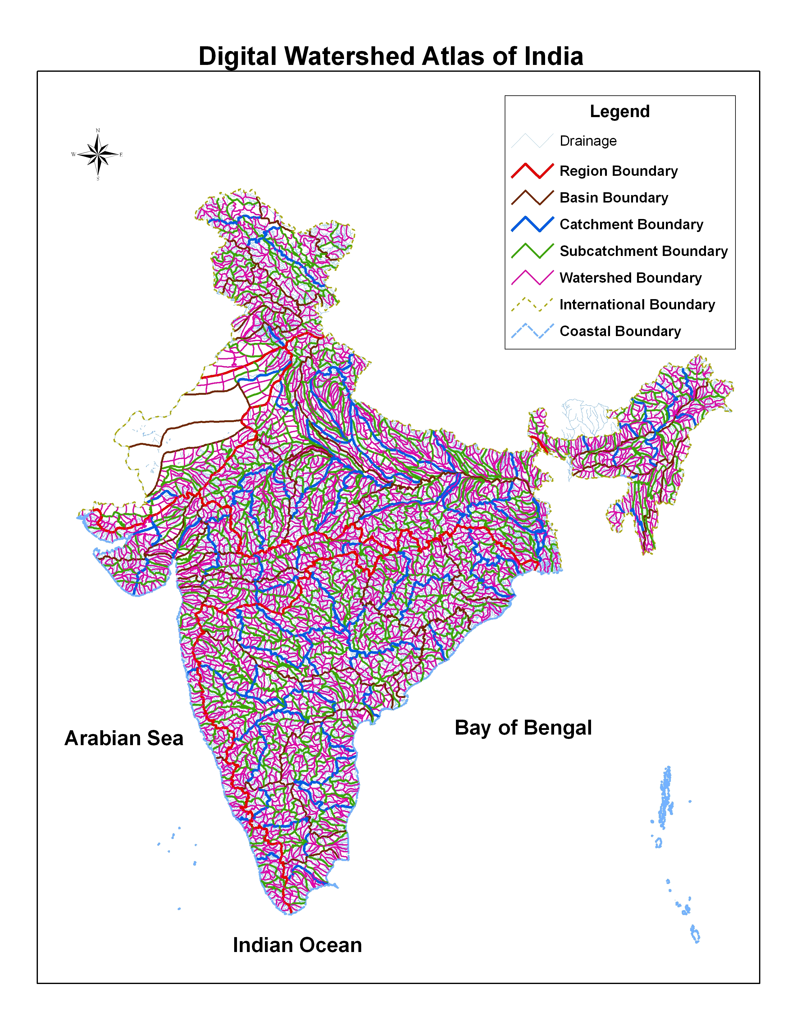
Digital
Watershed Atlas of India:- The Watershed Atlas of India published by Soil and
Land Use Survey of India has now been brought
under digital environment using GIS and RDBMS by the organization as step towards
development of Spatial Database not only to serve the country in a sustained manner but to
disseminate the information on line to the users through information technology The digital watershed atlas is customized in such a
way that it can be given to the users both River Resource Region and Basin wise or State
and Catchment basis. The beauty of the atlas is that the name of the river will blink on
the monitor when the cursor is placed on any part of the atlas. Subsequently, detailed
description of the watershed highlighting the area and the district and State it falls and
its linkages with main drainage system will follow. The digital atlas is going to be the
backbone of many future information systems and applications.
|